*Disclosure: This post contains affiliate links, and I may earn from purchases made after clicking those links. Disclosure Policy.
The fascinating looking Poinsett Bridge with its neat, almost eerie gothic style stone architecture, is a unique historic site in Upstate South Carolina.
It is the oldest remaining bridge in SC and might be the oldest in the entire southeastern US.
It’s easily accessible from much of the upstate, and not far off I-26, making it easy to visit as an addition to a visit nearby or just a unique stop if you happen to be road tripping through South Carolina.
Susana and I visited the Poinsett Bridge from Greenville, SC and thought it was worth the drive out here.
If you’d like to visit the historic Poinsett Bridge yourself, read on to learn how to visit, what you can see there, and a bit about its history!
*Poinsett Bridge Closure 2025-2026*
If you are looking to visit the Poinsett Bridge, I have some temporary bad news.
The oldest bridge in South Carolina will be closed for preservation work through the winter of 2025 and 2026.
According to this press release from the SC Department of Natural Resources, the entire Poinsett Bridge Heritage Preserve will be closed from September 29,2025 until March 31, 2026.
During this time, the mortar of the bridge will be replaced, some stones will be replaced, the bridge will be resurfaced, and a guardrail will be added.
So, unfortunately, it looks like the bridge will not be visitable until April 1, 2026.
As that date approaches, and/or the project is finishing, I will do my best to update a reopening date. In the meantime, I hope you’ll still enjoy the photos here and will bookmark this page to plan a future visit!
History of the Oldest Bridge in South Carolina
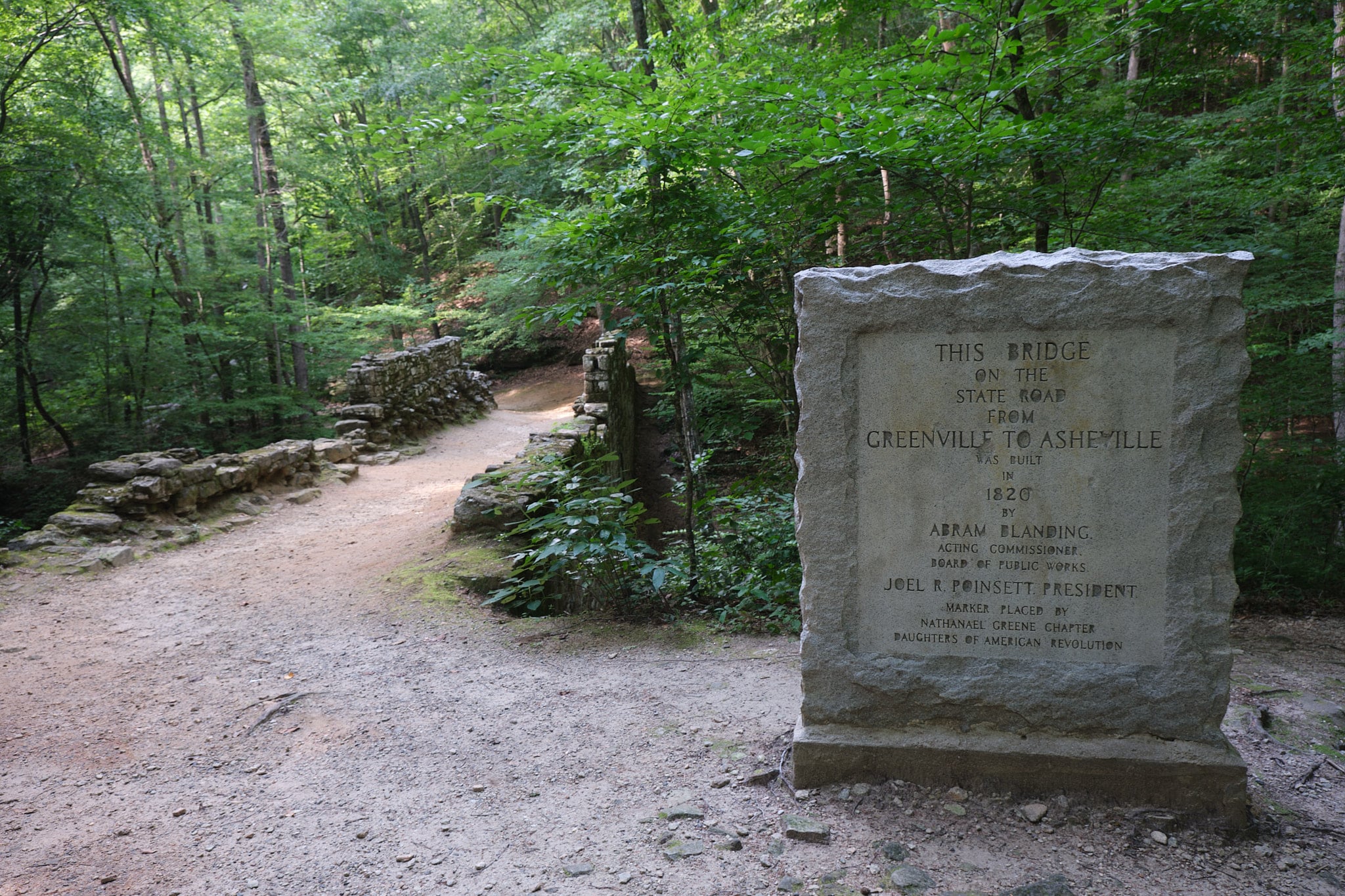
The Poinsett Bridge was built in 1820, making it over 200 years old.
It was a key part of the historic South Carolina State Road that connected Charleston to Asheville, passing through Columbia and Greenville on the way. This road was sort of the I-26 of its time.
The bridge was constructed to cross the Little Gap Creek.
There were certainly bridges built before it.
As a matter of fact, there were actually two other bridges nearby built as part of this section of the road.
However, neither they or any other bridge built earlier remain standing.
That makes it the oldest bridge left standing in South Carolina.
In 1970, it was added to the National Register of Historic Places.
When researching a bit more to write this post, I actually found the Poinsett Bridge story to be fairly interesting, due in large part to the history of both its namesake and likely architect.
Joel Roberts Poinsett
The Poinsett Brridge was named after Joel Roberts Poinsett.
Who was Joel Roberts Poinsett?
Poinsett was a native Charlestonian with a penchant for adventure, spending much of his life abroad, reportedly even dining with Tsar Alexander during his travels in Russia.
He later spent time in Chile and Argentina as sort of a special agent employed by US government to report on and provide support for the independence movements.
After returning to the US, he was the president of the South Carolina Board of Public Works from 1817-1819.
At the same time, he was also serving as a state legislator where he was on the Committee on Internal Improvements and Waterways.
So, he was intimately involved in the development of infrastructure in the state.
He had been impressed with the infrastructure he had seen during his travels in Europe and hoped to promote further development of the Palmetto State through improved infrastructure and public works projects.
One of the projects he was most keen to develop and promote was the idea of a State Road that would connect the coastal port of Charleston to inland trading hubs in North Carolina, Eastern Tennessee, and beyond.
He began working closely with Abram Blanding, the acting Commissioner of Public Works to construct the road.
The bridge that’s named in his honor that would be crucial in completing that road.
Poinsett went on to serve as a representative of South Carolina in the US Congress beginning in 1820, the year of the construction of the bridge.
While serving in the House of Representatives, he also served as an envoy to Mexico, before resigning in 1825 to become Minister to Mexico.
He concluded the first official treaty between the US and Mexico in 1828.
During a visit to Mexico, he was dazzled by a plant called the Flor de Nochebuena, literally Christmas Eve flower in Spanish.
He sent examples of the flower home, and it eventually became known as the poinsettia in the US.
Later he served as Secretary of War under Andrew Jackson, including during the Trail of Tears.

Robert Mills Connection to the Poinsett Bridge
The Poinsett Bridge is believed to have been designed by Robert Mills.
The original plans for the bridge were lost, but he is widely credited as the designer.
Mills, a native South Carolinian, was possibly the first native-born professionally trained architect in the US, although that claim is disputed.
What’s not disputed is that he designed a slew of buildings in Charleston, the rest of South Carolina, and a number of buildings elsewhere, including in the nation’s capital.
Mills designed the Washington Monument, the US Treasury Building, the former General Post Office, and the old US Patent Office that is now the Smithsonian American Art Museum and National Portrait Gallery in Washington, DC.
His connection to the Poinsett Bridge was likely due to his position as the commissioner of the Board of Public Works of South Carolina, a position he began in 1820, the same year as the bridge’s construction.
It seems a given that he at the least played an oversight role in its construction.
It is possible, however, that his predecessor William Jay designed the bridge, and I found at least one source that claims Poinsett designed it.
Since the original plans were lost and there is no other clear record, it’s impossible to confirm. However, Mills is generally considered to have been the designer and widely credited as such.
If you’re interested in learning more about the bridge’s history, there’s a great story map page on the SC DNR website that delves into the history of the bridge’s construction.

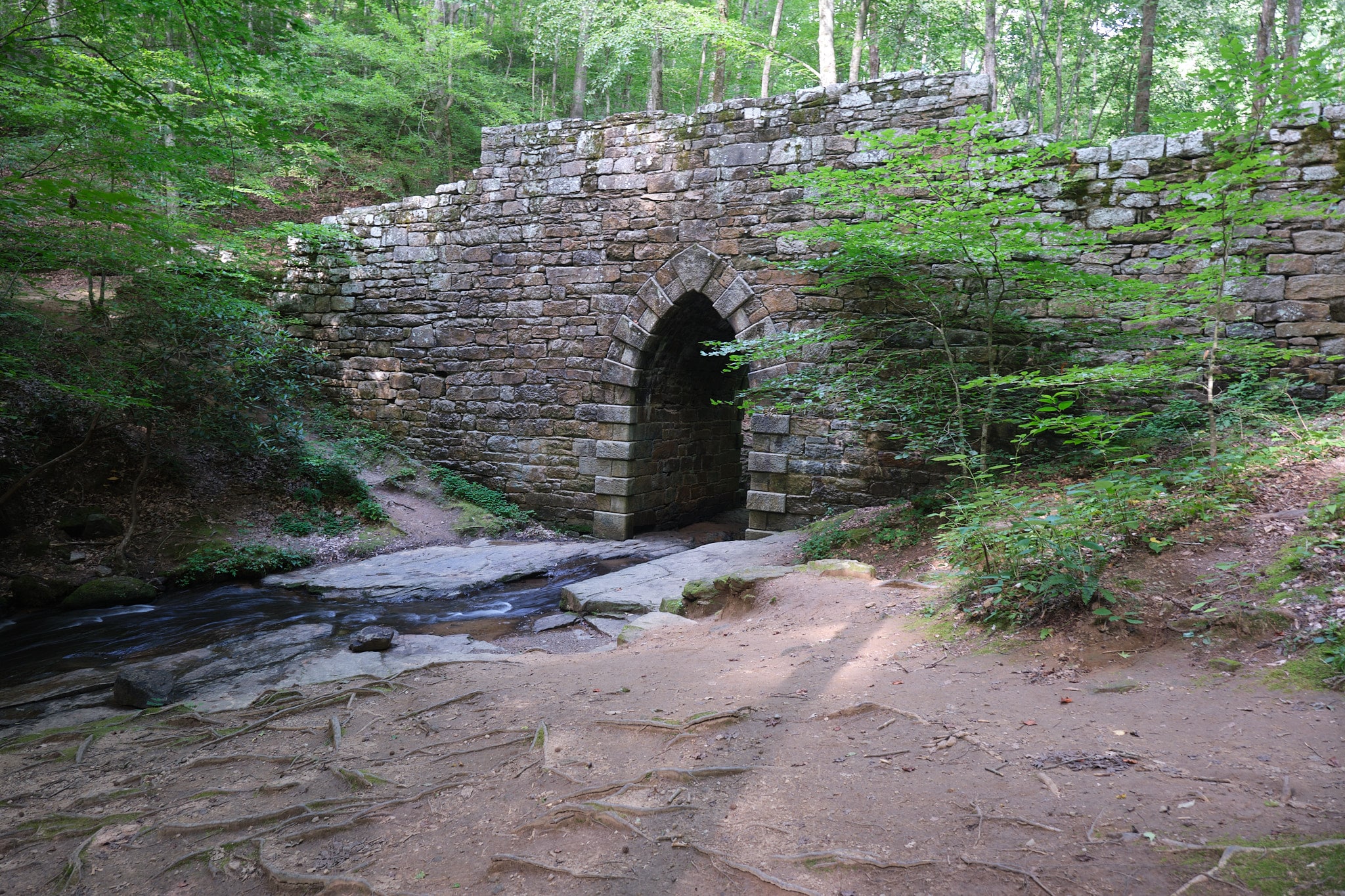
Design of the Poinsett Bridge
The bridge is unique not just for its fascinating look.
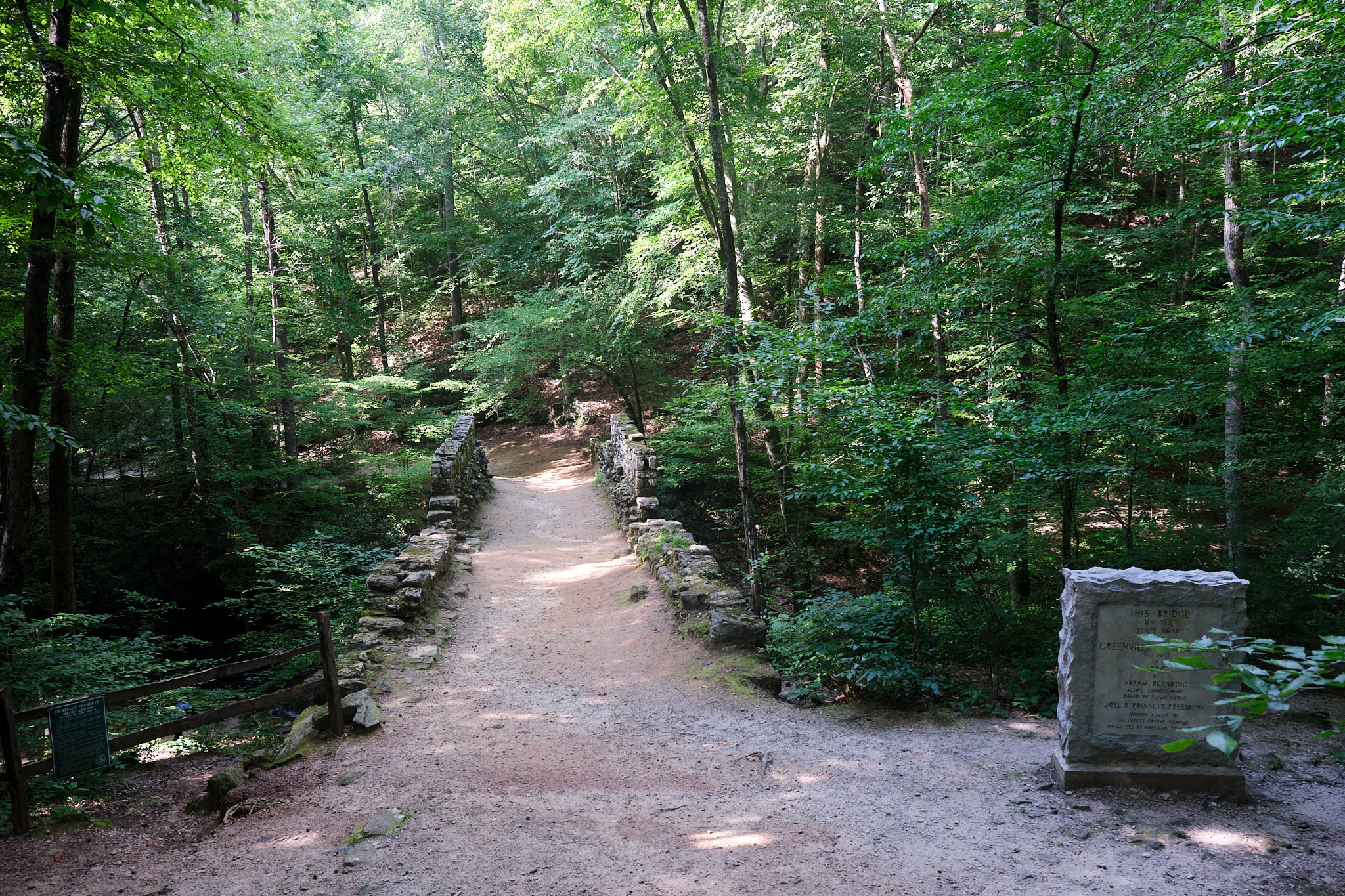
The bridge is also just 130 feet long, and feels even shorter when walking across
The gothic style arch and the use of stone without concrete mortar was an uncommonly complex and unique design, especially in what was an extremely remote part of the state at the time.
What struck me about the bridge is that it seems particularly elaborate and fancy for the crossing of a relatively small creek.
Even the opening for the creek is only a couple feet wide, so it’s not like the river used to be much wider.
Perhaps it was prone to flooding, and that’s why they wanted to build a taller, well reinforced bridge.
Regardless, it’s a neat design, and it looks more like something out of medieval or Renaissance era Europe than the early industrial United States.

What You Can See at the Poinsett Bridge Today
Susana and I just popped by and took some photos of the bridge, but it is actually part of a larger park and protected area known as the Poinsett Bridge Heritage Preserve.
The preserve protects nearly 400 acres around the bridge today as a result of large addition to the preserve in mid-2024.
There were trails from the bridge into the woods.
According to that press release linked above, the area is home to many rare plants, 73 bird species, and even 5 bat species, including one considered threatened.
We were just stopping in on the way back to Columbia from a training workshop I attended in Greenville.
For what it’s worth, we got put up in the Courtyard by Marriott in Downtown Greenville, and it was great if you’re looking for a hotel in the Greenville that offers easy walking access to everything downtown.
We saw this nearby and decided to check it and the nearby Campbell’s Covered Bridge while we were here, so we didn’t explore the trail.
It looks like it would be neat to check out if you enjoy hiking and have more time than we did though. I haven’t been able to find a good map or info on how long the trail is.

As we approached the bridge from the road, it’s hard to get an idea of just how large it is, since it is not particularly long, the walls on either side are not that high, and the ground, at least today, is earth.
The forest on either side hides how high it is above the creek.
However, once we walked out on the bridge, we got a sense that it was fairly elevated over the creek.
The walls along the sides reminded me of old stone walls in farm fields.

The base of the bridge certainly didn’t look like a common farm wall though!
Once we climbed down on the little paths on either side of the bridge, we were able to get a good look at the base of of the bridge.
It’s really impressive stone work, dominated by the gothic style archway in the middle.
The arch is 14 feet high.
Honestly, it looks like it should be even older than 1820, like from a medieval castle or something.
I understand why some claim the Poinsett Bridge is haunted.
We didn’t see any ghosts, or trolls for that matter, but we did really enjoy getting a view of the bridge.

It’s very neat, and you can walk along the creek in either direction from both sides of the bridge.
Be sure to poke your head under the archway!
I thought the view from the path down to the left when coming from the road was the best spot to view and photograph the bridge.
It’s also got a nice little clearing along the creek that would be good for a picnic and maybe even to wet your feet a bit on a hot day.

A Few Practical Tips
The area is a tad remote, so I wouldn’t want to drive through here much past dark if I didn’t know my way around.
Also, be sure to watch for deer.
We didn’t see any around the Poinsett Bridge but did have one run out not all that far ahead of us when heading from the Campbells Covered Bridge out to I-26.
It was enough to give us a scare and start to slam on the brakes.
Speaking of animals, you’ll be in the woods next to stream, so watch out for cottonmouths and other snakes.
Also, I’d definitely encourage taking along some bug spray, especially if you’re going to walk along the trail.
Even in the 10-15 minutes we stopped by the bridge, I could tell I got bit a few times.
There are no public restrooms, so make a pit stop on the way if you need it or find a good bush.

How to Get to the Poinsett Bridge
The Poinsett Bridge is in a fairly remote area, but it’s not too far off a few state highways, and really isn’t too far off I-26 either
I’ll run through a few quick directions from major places below.
Note, there is a small turn off and parking area right across the street from the bridge. There isn’t a big sign or anything for the bridge itself, but there is a yellow pedestrian crossing sign.
It wasn’t too difficult to see coming up the hill, but since it’s around a curve, it might be hard to spot if you’re coming from the other direction.
Also, we didn’t get a good enough phone signal to use GPS directions when we were leaving, so you may want to make sure you remember the way back out to the highway or wherever you’re heading next.
Our signal did return as soon as we got back out to a main road, and it’s probably worth saying we have a budget carrier, so you may get better service than we did.

Poinsett Bridge from Greenville, SC
We came here directly from Greenville.
It took just a bit over a half hour and was an easy drive.
There are actually two viable routes to get to the Poinsett Bridge from Greenville: on Highway 25 or on Highway 253.
We did Highway 25.
Leaving downtown Greenville, you’ll need to get on Highway 276 West towards Traverer’s Rest (interestingly enough this stretch of road is also known as Poinsett Hwy in Greenville, SC).
As you arrive into Traveler’s Rest, get on US-25 North. Look for signs to Asheville.
Shortly after crossing over Highway 11, you’ll want to veer right onto Old Highway 25 (you’ll see signs).
You’ll eventually take a right on to a little road that starts along the highway and then veers off called Callahan Mountain Road.
This road winds for a bit and I thought it was kind of neat seeing some old rusted up trucks and cars in people’s yards along the way.
Follow that for a bit, and you’ll see a small parking area on the right heading up a hill.
That’s your stop.
The bridge is just across the street.
If you want to go on Highway 253 North, you’ll just take it until it becomes North Tigerville Road just past Hwy 11.
Then, head right on Hwy 912/Old State Hwy 11/State Rd S-23-912.
Next, turn left onto Callahan Mountain Road just after a curve.
This is coming from the opposite direction, so you’ll be heading downhill and looking for the parking area on the left and the bridge on the right.

Poinsett Bridge from Spartanburg, SC or I-26 West
To get from Poinsett Bridge from Spartanburg, the midlands, and much of the rest of South Carolina, it’s best to take I-26 W towards Asheville.
For reference, it should take about 45 minutes from Spartanburg and a bit over 2 hours from Columbia to get here.
You’ll want to take Exit 5 to get on SC 11-South (turning left if exiting from I-26 W).
You will need to head right at a fork to get on Hwy 912/Old State Hwy 11/State Rd S-23-912.
You’ll fork again to the right onto Callahan Mountain Road, and the bridge will be on your right coming down hill, parking area to the left.

From Asheville, Hendersonville, or I-26 East
If you’re coming from Asheville, expect to spend about an hour to get to the Poinsett Bridge. From Hendersonville, it should take only about a half hour.
Heading east on I-26 towards Columbia/Spartanburg, you’ll want to take Exit 54 for US-25 South. Look for signs that say US-176/NC-225/Greenville.
You’ll follow US-25 South across the state line into SC, and shortly afterwards, you’ll need to turn turn right to circle around and turn right again to get on Beaver Dam Road/Hwy 177 heading east (there is a sign shortly before the turn that says Beaver Dam Road next right).
When you come to the end of this road, you’ll turn left onto Old Hwy 25.
A short distance ahead, you’ll veer right onto Callahan Mountain Drive.
You’ll approach the bridge on the left and the parking lot on the right heading uphill.

From Charlotte or I-85 South
It should take just a bit under 2 hours to get to the Poinsett Bridge from Charlotte.
You have two options.
You can take I-85 S to exit 70 and get on I-26 W just outside Spartanburg.
Then, you’ll follow the instructions above from Spartanburg/I-26 W, taking SC-11 from Exit 5.
Or, you can take exit 92 and get on SC-11 S earlier just outside of Gaffney.
This will add approximately 15 minutes to the route but is more direct and I imagine a tad more scenic.

How to Get to the Nearby Campbell’s Covered Bridge
After our stop at the Poinsett Bridge, we headed over to also see nearby Campbell’s Covered Bridge, which was totally worth it.
It’s not far and seeing these two historic bridges together is easy enough and likely won’t put you too far out of the way to continue on to wherever you’re headed next.
There’s a few different routes you can take to get between the two bridges. They all take about 15-20 minutes.
Regardless of which route, you’ll want to turn right out of the parking area and head up hill. When you come to the fork and first cross street, keep left, then turn left onto Hwy 912.
When you get to the intersection with SC-11, you can head straight to continue on to N Highway 101, or you can turn left on to SC-11 N.
If you go straight, you’ll turn left onto SC-414, then right on Pleasant Hill Road, and quickly right again onto Campbell Covered Bridge Road.
If you went left on SC-11, you’ll take a sudden right after going around a curve onto Dill Road.
Then, you’ll turn left onto SC-414, where you’ll follow the same right turns on Pleasant Hill Road and Campbell Covered Bridge Road above.
There is a large parking area here.
Ready to visit South Carolina’s oldest bridge yourself?
Now you’ve got a complete guide to visiting the Poinsett Bridge near Greenville, SC for yourself.
It really is a neat stop and whether you’re spending some time in Greenville, Spartanburg, Hendersonville, or Asheville or just passing through the SC Upstate, it’s a worthwhile trip or detour to see something unique.
If you do go, I hope this guide was helpful in planning, and most importantly, you enjoy it.
Cheers and Happy Exploring!
Did you like this post?
If you’re into history, be sure to check out the South Carolina State Museum and Military Museum in Columbia.
1 thought on “Poinsett Bridge: The Fascinating Oldest Bridge in South Carolina”
Comments are closed.